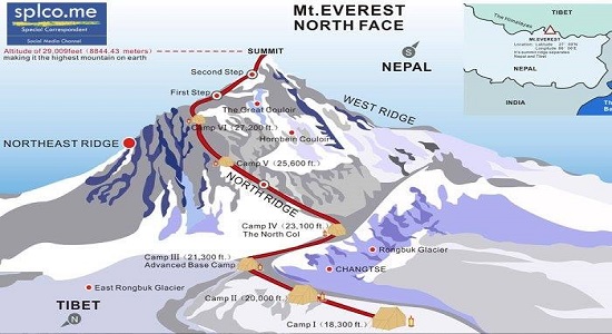
Nepal is set to begin measuring the height of Mt Everest on its own within two weeks after setting aside India’s proposal for a joint exercise to survey the world’s tallest peak in the wake of the devastating 2015 earthquake.

A secretariat has been set up for the work and officials said the task of measuring the height of Mt Everest will take two years and cost more than Rs 250 million.
Though India offered to jointly measure the height of Mt Everest with the Nepalese side, officials here rejected the proposal, saying the country would conduct the exercise on its own this time.
However, Ganesh Bhatta, director general of Department of Survey that is playing a leading role in the survey, contended Nepal’s decision shouldn’t be seen as a rejection of India’s offer.
“Before receiving the Indian proposal, we had already started the plan to measure the height with our own resources. So there is no question of rejecting or accepting the Indian proposal,” Bhatta said.
“It is a question of self-respect too. So we humbly declined India’s offer to become part (of the exercise). Second, once we measure the height of Everest, the capability of the Department of Survey will be strengthened and we will have more equipment for other tasks too,” he said.
Asked if there was any proposal from China to join the survey since Mt Everest is located along the border of the two countries, Bhatta said no such offer had made been made so far.
“But they have told us that they are ready to assist Nepal at any time if we need any help. If we need any help and support, we will seek support from both India and China,” he said.
In 2011, Nepal had planned to measure the height of Mt Everest and allocated Rs 8 million for the effort. The work was stopped when the finance ministry told officials not to use money for “unproductive works”.
After the great earthquake of 2015 and speculation that the height of Mt Everest could have been changed by the temblors and aftershocks, the government decided to measure the world’s tallest mountain.
“The most important thing is the data that will come out from the survey,” Bhatta said. “If foreigners measure the data, they will only provide us the height of the Everest but (they wouldn’t) share the critical data we need. If we measure it on our own, we can store the data and carry out analysis, which will remain our property and be useful for years.”
According to the first scientific measurement conducted in 1856, the height of Mt Everest is 8,848 metres. The new study will not only reveal the actual height but also show the impact of climate change on the mountain.
There has also been speculation of a possible shift in Mt Everest’s position following the 2015 quake, but there has been no scientific research to check these claims.
Bhatta said it is difficult for technicians to climb Mt Everest and authorities plan to train Sherpa porters, who are expert climbers, to carry the technical equipment needed to measure the height. The trained Sherpas will begin the measurements during the next climbing season.
The Department of Survey will take the help of international experts and scientists in the process, he added.
To make the findings credible and widely accepted, tools and methods such as GPS, gravity survey measurement, vertical height measurement and mathematical survey will be used along with direct measurement and triangulation.
Read also : Economic blockade by Modi Government reverse India's hold in Nepal


